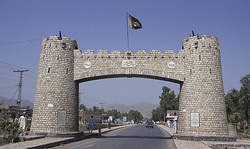
ISLAMABAD
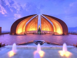
Tourism in Islamabad offers the traveller a vast array of choices from the many beautiful buildings, Mosques and of course Parliament. Islamabad is the capital of Pakistan; it is relatively young, the capital being moved from the hot, humid city of Karachi in the early sixties. There are wide-open boulevards, tree lined avenues and parks.
It is overlooked by the Margalla Hills and has a most pleasant climate with little or no wind. Animals and Scooter Taxis are not allowed in the capital, which makes for a pleasant environment.
Whilst touring Islamabad we will dine in Daman-e-Koh, which offers fantastic views of Islamabad whilst dining, where we will also see monkeys roaming the hills.
We will also tour Rohtas Fort, which is an easy 2-hour drive from Islamabad, where we will picnic in the open air.
Or let us take you on a 2-hour journey west of Islamabad to visit the famous Prince Malik Atta as seen on the Michael Palin show, where the dashing locals will race bulls and ride Stallions tent pegging, only the most fearless will ride.
Islamabad has many places of interest that you will wish to visit including many art galleries and museums. Rawalpindi is also within 15 minutes of Islamabad and is a bustling town full of life and bazaars. We offer the most comprehensive Islamabad holidays. You will have the opportunity to buy in Islamabad a stunning variety of goods from Kashmir silver to beautiful carpets.
Yet another Pakistan tourist attraction is the famous Air Safari offering travelers the opportunity to fly around K2 and take wonderful photographs.
From Islamabad we will also drive out through colourful scenery to Taxila where we will be guided through the ancient ruins and museum.
Islamabad also boasts the largest Mosque in Pakistan named after King Faisal of Saudi Arabia.Its pillar- less domed building can house more than 100,000 in prayer.
FAISAL MOSQUE
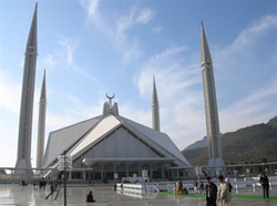
The Faisal Mosque is the largest mosque in Pakistan, located in the national capital city of Islamabad. It is shaped like a desert Bedouin's tent designed by Turkisharchitect Vedat Dalokay and completed in 1986.
It is situated at the north end of Faisal Avenue, putting it at the northernmost end of the city and at the foot of Margalla Hills, the westernmost foothills of the Himalayas. It is located on an elevated area of land against a picturesque backdrop of the Margalla Hills. This enviable location represents the mosque's great importance and allows it to be seen from miles around day and night.
The Faisal Mosque is conceived as the National Mosque of Pakistan and named after the late King Faisal bin Abdul-Aziz of Saudi Arabia, who supported and financed the project.
It is the largest mosque in South Asia and one of the largest mosques in the world. The Faisal Mosque was the largest mosque in the world from 1986 until 1993, when it was overtaken in size by the completion of the Hassan II Mosque in Casablanca,Morocco. Subsequent expansions of the Masjid al-Haram (Grand Mosque) of Meccaand the Al-Masjid al-Nabawi (Prophet's Mosque) in Medina, Saudi Arabia during the 1990s relegated Faisal Mosque to fourth place in terms of size.
LOK VIRSA
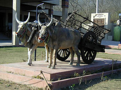
Lok Virsa Museum is situated in Islamabad, Pakistan. It displays the cultural heritage of Pakistani people. The living style of the different areas of Pakistan is exhibited here in statues, pictures, pottery, music and textile work. Lok Virsa is the finest cultural museum in Pakistan.
The Lok Virsa Museum also known as the Folk Heritage Museum run by the National Institute of Folk & Traditional Heritage represents art works towards preserving the living folk and traditional culture and crafts of Pakistan. It is located near Shakarparian Hills and has a large display of embroidered costumes, jewellery, woodwork, metalwork, block printing, ivory and bone work. Traditional architecture facades exhibiting such skills as fresco, mirror work and marble inlay; tile, mosaic and stucco tracery are also displayed.
Adjacent to the Lok Virsa Museum, the Lok Virsa Heritage Reference Library is well equipped with resource data on ethnography, anthropology, folk music, art, history and crafts. Books on culture, heritage, audio and video-cassettes of folk and classical vocal and instrumental music are available for sale at Lok Virsa’s sales centre
TAXILA
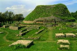
Just a short drive from Islamabad, this is one of the most important archaeological sites in the world. There are 18 locations in the area which are world heritage sites, but only 5% have been excavated.
This is the region from where Buddhism travelled to the far east - and Persians, Greeks and Hindus all subsequently left their mark. You can watch the sun set from the remains of a Buddhist monastery or wander through the streets of an excavated Persian city in the knowledge that there are two older ones buried below.
This is the region from where Buddhism travelled to the far east - and Persians, Greeks and Hindus all subsequently left their mark. You can watch the sun set from the remains of a Buddhist monastery or wander through the streets of an excavated Persian city in the knowledge that there are two older ones buried below.
MOHENJO-DARO
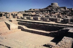
Mohenjo-daro (Mound of the Dead), is an archeological site situated in the province of Sindh, Pakistan. Built around 2600 BC, it was one of the largest settlements of the ancient Indus Valley Civilization, and one of the world's earliest major urban settlements, existing at the same time as the civilizations of ancient Egypt, Mesopotamia, and Crete. Mohenjo-daro was abandoned in the 19th century BC, and was not rediscovered until 1922. Significant excavation has since been conducted at the site of the city, which was designated a UNESCO World Heritage Site in 1980.
Architecture and urban infrastructure
Mohenjo-daro has a planned layout based on a street grid of rectilinear buildings. Most were built of fired and mortared brick; some incorporated sun-dried mud-brick and wooden superstructures. The sheer size of the city, and its provision of public buildings and facilities, suggests a high level of social organization. At its peak of development, Mohenjo-daro could have housed around 35,000 residents. The city is divided into two parts, the so-called Citadel and the Lower City. The Citadel – a mud-brick mound around 12 metres (39 ft) high – is known to have supported public baths, a large residential structure designed to house 5,000 citizens, and two large assembly halls.
The city had a central marketplace, with a large central well. Individual households or groups of households obtained their water from smaller wells. Waste water was channeled to covered drains that lined the major streets. Some houses, presumably those of wealthier inhabitants, include rooms that appear to have been set aside for bathing, and one building had an underground furnace (known as ahypocaust), possibly for heated bathing. Most houses had inner courtyards, with doors that opened onto side-lanes. Some buildings had two stories.
In 1950, Sir Mortimer Wheeler identified one large building in Mohenjo-daro as a "Great Granary". Certain wall-divisions in its massive wooden superstructure appeared to be grain storage-bays, complete with air-ducts to dry the grain. According to Wheeler, carts would have brought grain from the countryside and unloaded them directly into the bays. However, Jonathan Mark Kenoyer noted the complete lack of evidence for grain at the "granary", which, he argued, might therefore be better termed a "Great Hall" of uncertain function.
View of the site, showing an ordered urban layout.Close to the "Great Granary" is a large and elaborate public bath, sometimes called theGreat Bath. From a colonnaded courtyard, steps lead down to the brick-built pool, which was waterproofed by a lining of bitumen. The pool measures 12m long, 7m wide and 2.4m deep. It may have been used for religious purification. Other large buildings include a "Pillared Hall", thought to be an assembly hall of some kind, and the so-called "College Hall", a complex of buildings comprising 78 rooms, thought to have been a priestly residence.
Mohenjo-daro had no circuit of city walls, but was otherwise well fortified, with guard towers to the west of the main settlement, and defensive fortifications to the south. Considering these fortifications and the structure of other major Indus valley cities like Harappa, it is postulated that Mohenjo-daro was an administrative center. Both Harappa and Mohenjo-daro share relatively the same architectural layout, and were generally not heavily fortified like other Indus Valley sites. It is obvious from the identical city layouts of all Indus sites, that there was some kind of political or administrative centrality, but the extent and functioning of an administrative center remains unclear.
Mohenjo-daro was successively destroyed and rebuilt at least seven times. Each time, the new cities were built directly on top of the old ones. Flooding by the Indus is thought to have been the cause of destruction.
BUDDHIST REMAINS TAKHT BHAI
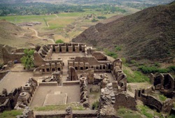
Takht Bhai is a Buddhist monastic complex dating to the 1st century BCE. The complex is regarded by archaeologists as being particularly representative of the architecture of Buddhist monastic centers from its era. It was listed as a UNESCO World Heritage Site in 1980.
The word Takht Bhai may have different explanations. In Sanskrit, takht means "well" and bhai means "on a high surface", so the whole word means "well on a high surface". In Persian, takht means "throne". The ruins are located about 15 kilometers from Mardan in Pakistan's Khyber-Pakhtunkhwa Province. A small fortified city, dating from the same era, sits nearby. The ruins also sit near a modern village known by the same name. The surrounding area is famous for sugar cane cultivation.
STRUCTURE
There are four main areas of the Takht Bahi complex:
- The Stupa Court, a cluster of stupas located in a central courtyard.
- The monastic chambers, consisting of individual cells arranged around a courtyard, assembly halls, and a dining area.
- A temple complex, consisting of stupas and similar to the Stupa Court, but of later construction.
- The Tantric monastic complex, which consists of small, dark cells with low openings, which may have been used for certain forms of Tantric meditation.
LAHORE
Every Pakistani you meet will remind you of the old adage that if you haven't been to Lahore you haven't lived. The old city looks like a medieval costume drama, with horses, donkeys and ox-drawn carts transporting everything from stacks of hay to blocks of ice. In the narrow streets of the spice market, huge hessian sacks contain all manner of extravagant herbal cures, including died hair from corn on the cob for kidney pain, gum crystals for back pain and tree bark for flu. There are also mounds of chalky green henna and blue clothes dye "to turn white shirts into school uniform."
The incredible Mughal buildings of Lahore Fort and Badshahi mosque - one of the world's largest - are must-sees; eat dinner on the terrace of the converted Haveli Cocco's Den for a floodlit bird's-eye view. Meanwhile, New Lahore, with its Liberty market and numerous coffee shops (albeit serving Nescafe), presents the vibrant, modern face of Pakistan.
The incredible Mughal buildings of Lahore Fort and Badshahi mosque - one of the world's largest - are must-sees; eat dinner on the terrace of the converted Haveli Cocco's Den for a floodlit bird's-eye view. Meanwhile, New Lahore, with its Liberty market and numerous coffee shops (albeit serving Nescafe), presents the vibrant, modern face of Pakistan.
THE KARAKORUM HIGHWAY
Opened in 1986, the KKH, as it is fondly referred to, is the highest road in the world, winding through the Karakorum mountain range and connecting to China through the Khunjerab Pass at an altitude of nearly 5000 metres. It is the only way to the tourist attractions of the Northern Areas, but negotiating its twists and bends around unprotected sheer drops is an adventure in its own right.
The road connects many villages whose only sign of modernisation is the sponsored paintwork of Pepsi and Nestle that decorate the shops. Along the way you also pass several hundred spectacularly painted Bedford trucks. These are one of the defining features of Pakistan, costing up to three years' wages to adorn and featuring intricate designs of birds and trees. Several hundred metres below, the Indus thunders past grey silt beaches.
The road connects many villages whose only sign of modernisation is the sponsored paintwork of Pepsi and Nestle that decorate the shops. Along the way you also pass several hundred spectacularly painted Bedford trucks. These are one of the defining features of Pakistan, costing up to three years' wages to adorn and featuring intricate designs of birds and trees. Several hundred metres below, the Indus thunders past grey silt beaches.
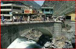
BALAKOT
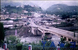
The gateway to the Kaghan Valley, is a little way up the Kunhar River, 72 kms (45 miles) from Abbotabad. The small bustling town with its colorful bazaar and the old wooden bridge over the rushingKunhar river are set up with a picturesque backdrop of pine covered slopes. The huge boulders on these slopes dotted with countlessbullet holes tell the story of the battle between the Muslims and the Sikhs fought in the mid 19th century. Its main road connects the town with Shogran and Naran the main tourist attractions of the Kaghan Valley.
KAGHAN VALLEY
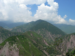
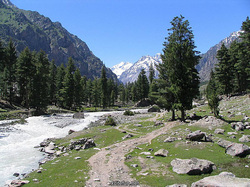
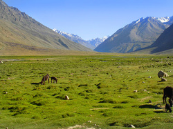
Terraced from river to hilltop and covered in forests of huge Himalayan pine, the Kaghan Valley is one of the most beautiful in Pakistan and is reminiscent of the alpine scenery of Europe. Kaghan is just on the edge of the monsoon belt, so there is no need for irrigation here. The slopes are steep, and villages cling precariously to the sides of the hills, the tops of which are often hidden by clouds. Kaghan is not on the normal tourist route: it is for the lover of nature, hiking, fishing and other outdoor pleasures.
Most confusingly, there is no Kaghan River, rather, the Kunhar Riverflows through the Kaghan Valley, down from high in the Indus Kohistan to join the Jehlum at Muzaffarabad. The valley is over 160 kilometers (100 miles) long and climbs from about 900 meters (3,000 feet) at Balakot to 4,173 meters (13,690 feet) at the Babusar Pass. The road through the valley and up over the Babusar Pass to Chilas on the Indus opened in 1898; it was the main route to the Northern Areas and Gilgit before the Karakoram Highway was opened in 1978. Closed for most of the year by heavy snow, the Babusar Pass is only jeepable for the short summer months.
Most confusingly, there is no Kaghan River, rather, the Kunhar Riverflows through the Kaghan Valley, down from high in the Indus Kohistan to join the Jehlum at Muzaffarabad. The valley is over 160 kilometers (100 miles) long and climbs from about 900 meters (3,000 feet) at Balakot to 4,173 meters (13,690 feet) at the Babusar Pass. The road through the valley and up over the Babusar Pass to Chilas on the Indus opened in 1898; it was the main route to the Northern Areas and Gilgit before the Karakoram Highway was opened in 1978. Closed for most of the year by heavy snow, the Babusar Pass is only jeepable for the short summer months.
MURREE
Murree is a hill station and summer resort and the administrative centre of Murree Tehsil, which is a subdivision of Rawalpindi District and includes the Murree Hills.
Murree was the summer capital of the British Raj in the Punjab Province (British India). A popular tourist destination, Murree is often referred to as the "Queen of Hills," a term coined by the British. Located in the north-west Himalayas at an average altitude of 2,291 metres (7,516 ft), the city of Murree, draped in forests of pine, and oak, experiences pleasant summers and cold, snowy winters. The city is famous for its buildings styled in tudorbethan and neo-gothic architecture dating from the colonial era. Murree is located along the Islamabad-Murree Highway, some 58.3 km (36.2 mi) northeast of Islamabad.
Buildings and Tourist Attractions
Murree houses headquarters of 12th infantry division of Pakistan Army and large number of educational and training institutions. Combined Military Hospital established to cater the needs of civilian population of Murree and adjoining areas. Pakistan Air Force also maintains base at Lower Topa. For administrative purposes the military areas of Murree are divided in two separate cantonments, Murree Cantonment and Murree Hills Cantonment. Murree Houses residence for Punjab Governor at the Kashmir point. The imposing building was built in nineteenth century by the British. There are Punjab and Sindh Houses to cater needs of the provincial government. Similarly, there are Rest Houses for the Judges of Supreme Court and Lahore High Court. A large number of government, semi government and private departments and institutions maintain guest houses in Murree. A number of diplomatic missions based in Islamabad established their camp offices in Murree in the 1960s. The same however are seldom used now. Adjacent to Murree is the Galliat region of North West Frontier Province which includes Nathiagalli, Ayubia, Khanspur, Dunga Galli, Khairagalli and Changla Galli. Before the British rule whether part of Rawalpindi District of Muzaffarabad, Murree and Galiat have been part of same administrative unit, however in 1850 the British decided to divide them between Rawalpindi and Hazara. Howevere despite divided by provincial boundaries, Murree and Galliat are inseparable both geographically, culturally, linguistically as well as from the point of view of the tourists. Murree serves as a gateway to Galliat.
In recent years Bhurban and New Murree (Patriata), have also developed as a tourist centre. The whole Murree Galliat region is known for its scenic beauty. Mountains overhung with pines and oaks, bubbling with gurgling springs, crisscrossed by rivulets, dotted with sprawling lawns and orchards overloaded with fruits present a nice spectacle. A fine view of the snowy peaks of Kashmir is to be had on a clear day, and the crest of Nanga Parbat can sometimes be seen. Bhurban, boosting with a five star Pearl Continental Hotel and a nine hole Golf course has cropped recently as another tourist attraction in the area. Lying at an altitude of 6000 ft, Bhurban is situated at a distance of 13 kilometers from Murree on one of main roads leading to Azad Kashmir. The Punjab government is said to have plans to develop New Murree city at Patriata fifteen kilometers southeast of Murree. The Punjab Tourism department constructed resorts amidst the forests on the Patriata ridge in 1987 as well as a 3 kilometer sky slope from the top of Patriata ridge to Gulara Gali (not functioning currently). Patriata is connected with Islamabad and Murree through a number of all weather roads.
AYUBIA
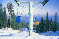
24 kms beyond Murree lies the enchanting hill resort ofAyubia, named after Field Marshall Ayub Khan. A cluster of 4 different villages and chair lift to a hill park greet the visitors. Nathiagali, at an elevation of 2500 meters (8200 ft) is the highest and most majestic of all the Gallis. Clouds trapped amidst pine forest are a common site; pink maple chestnuts blossoms add an unforgettable fragrance to the air. Majestic oaks complete this idyllic picture - truly an exhilarating experience.
KHYBER PASS
The legendary Khyber Pass in the North West Frontier is a 53 Kilometer passage through the Hindu Kush mountain range. It is the most famous passageway to the Himalayas. It connects the northern boarder of Pakistan with Afghanistan.
On the north side of the famous Khyber Pass rises the towering, snow-covered mountains to the Hindu Kush. Conquering armies have used the Khyber Pass as a point of entry or their invasions; in fact it has witnessed countless invasions.
British troops defended the Khyber Pass on the British – Indian side. Particularly well known is the battle of January 1842, in which about 16,000 British and Indian troops were killed.
One cannot talk of the Khyber Pass without also mentioning the Khyber Rifles , during the British rule the Khyber rifles was one of the eight ‘Frontier Corps” or para-military units recruited from tribesmen of the North West Frontier. The headquarters of the Khyber Rifles was at Landi Koltal and their prime role was to guard the Khyber Pass.For hundreds of years, great camel trains traveled through the Khyber Pass, bringing goods to trade. These merchants brought luxury silks and fine porcelain objects from China to the Middle East.
The Khyber Pass today has two highways one for motor traffic and the other for the traditional caravans. A railway line also travels to the head of the pass. This was built in the 1920s.
Whilst we are touring the Khyber Pass we will visit Peshawar and stay at one of the cities excellent hotels. Peshawar is the gateway to Afghanistan, which is situated at the mouth of the Khyber Pass.
Peshawar is the capital of the North-West Frontier Province. The name Peshawar means High Fort in Persian. During its history, the city was one of the main trading routes on the ancient Silk Road
A trip to Peshawar is not complete without visiting The Khan Club , which is a hotel from a by-gone era. The hotel has been fully restored and the result is magnificent. It is located in the oldest and most historic part of Peshawar. Each room has its own ‘jeweled’ theme.
Wherever you meet the famous Pathans of the North West Frontier region they will greet you with their overwhelming hospitality.
KALAM
Kalam is at 2100 meters, it slopes down gradually, terminating in a sharp drop to the main roadway and river. Upper Swat or Kohistan belongs culturally to the northern region as the architecture of the old mosque and the carvings of wooden pillars, window frames and door jambs indicate. Although there is no road from here to Chitral or Gilgit, the upper northern cultural influence must have filtered in along the food trails. This region is the boundary marking cultural changes from south to north. Kalam has a tranquil air and a pleasant climate during the day, though nights tend to be cold. On a clear day you can see the 5918 meter high Mt Falaksair from the upper section of the town. In the north-east of the valley its snow-clad upper slopes and peak rise above dense, lush forests. The river rushes through the town, right across from the old mosque. The wooden mosque of Kalam is the highlight of the whole valley & worth paying a visit.
GARAM CHASHMA
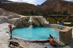
"Garam" means "Hot" and "Chashma" means "Spring". 45 kms north-west of Chitral, these Hot Sulphur Springs are known around the world for curing skin diseases, gout, rheumatism and headaches. The paved road follows the south bank of Lutkho river through a steep-sided gorge and emerges into the green and wooded valley guarded by a mud walled fort. This is the picturesque Lutkho valley which arcs north-west from Chitral to the Afghan frontier. It is a scenic, stark chasm of barren red rock walls and precipitous scree slopes, punctuated by incredibly green oases in occasional spots of bottom land. Rice and corn crops are watered by intricate irrigation systems, on terraces walled off by generations. A hard land fitting to the large Afghan refugee population which now shares living space with their native brothers.
DIR(DEER)
The independent Kingdom of Dir was absorbed into Pakistan only in 1962. Since one of the main trade routes from Eastern Afghanistan passed through lower Dir, there are several places of historical interest to be seen along the road among which Talash Valley, Kat Kala Fort and Timargarha are quite rich in theirarchaeological heritage left by the Aryans , Buddhists, Hindus and Muslims. None of these remains has been excavated, but they date from the second to the ninth century. Dir has a well wooded countryside with fine views. This beautiful town is inhabited by the upright, fierce yet very hospitable Pathans whose prestige is earned, maintained and avenged by a bullet.
CHITRAL
Chitral forms the North-Western roof of the Indian Sub Continent. The rugged Hindukush range comprises Chitral's Northern and Westerly borders while the imposing Hindu Raj mountains isolate it from the South. This isolated valley was once in the domain ofAlexander who marched through Chitral in 327 B.C. The Adamzada, the old ruling clan, proudly traces the linkage to the 14th century Tartar Emperor, Tamerlane. These governors called Mehatars dominated the state for 350 years until about 1960 when Chitral's statehood ended. Now Chitral is directly governed by Pakistan. The highest mountains of the Hindukush, Tirich Mir (25,264 ft) over shadows the Chitral town.
The best way to see the petite town of Chitral is on foot. The walk tour may begin by visiting the Shahi Mosque, built by the Mehatars, overlooking the Chitral river. The highest mountain of the Hindukush, Tirich Mir (7788 meters) solemnly overlooks the entire town. Chitral Fort, a grim imposing building that tells the tales of the days of the siege of Chitral in 1895. The guns of Cols Kelly and Roberts, Gen Low and Captain Ross are well maintained in the fort. Chitral Bazaar is known for hunting semi precious stones & handicrafts; such as waist coasts, belts, caps, woolen rugs, silver jewelry, embroideries, shoes, musical instruments and baskets.
The best way to see the petite town of Chitral is on foot. The walk tour may begin by visiting the Shahi Mosque, built by the Mehatars, overlooking the Chitral river. The highest mountain of the Hindukush, Tirich Mir (7788 meters) solemnly overlooks the entire town. Chitral Fort, a grim imposing building that tells the tales of the days of the siege of Chitral in 1895. The guns of Cols Kelly and Roberts, Gen Low and Captain Ross are well maintained in the fort. Chitral Bazaar is known for hunting semi precious stones & handicrafts; such as waist coasts, belts, caps, woolen rugs, silver jewelry, embroideries, shoes, musical instruments and baskets.
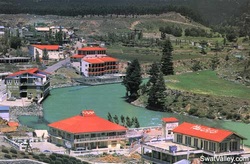
BAHRAIN
At 1400 meters Bahrain is another tourist attraction of Swat located at the picturesque junction of the roaring Swat River and the rushing Bahrain Nulla. The one lane bazaar offers colorful embroideries, handicrafts and local antiques. There are dozens of small hotels and restaurants with their balconies overlooking the rivers. This is an interesting area for explorers, who could stumble on important archaeological findings. From here the road starts to climb steeply towards Kalam. The bare mountains close in on the road, which drops away precipitously to the river. Beyond Bahrain isKohistan where the Pushto tribe gives way to the Torwalis and Bushkaris.
SKARDU
Perched at a height of 7500 Ft, Skardu is located amidst an impressive landscape, towering mountains, deep gorges, cascading waterfalls, creeping glaciers and quiet lakes. Skardu is in the heart of a towering frontier land. To its north lies the Sinkiang province of China, to the south Kashmir, to the West Gilgit and to the east the district of Ladakh in India. Skardu is the trekker and mountain climbers paradise. Nowhere can you find such a collection of lofty peaks and glaciers .The Baltoro Glacier, the best known, is that spectacular conjunction of Godwin Austen and Baltoro glaciers called Concordia, lying in the heart of the most heavily glaciated region outside the polar areas. Within a radius of 12 miles rise six peaks over 20,000 Ft. This is the center of the densest concentration of lofty peaks on earth. Some of these magnificent mountains in the Karakoram range are Masherbrum (25,600 Ft), Mustagh tower (23,690 Ft), K-2 (28,741 Ft), Broad Peak (26,400 Ft), Gasherbrum IV (26,810 Ft), Sia Kangri (24,350 Ft) Golden Throne (23,989 Ft), Mitre Peak (19,718 Ft), Chogolisa (25,110 Ft) and Hidden Peak (26,470 Ft) and many others.
BESHAM
BESHAM is a major village cut into the hillside above the Indus along the Karakoram Highway. Half way between Islamabad and Gilgit, Besham has become a hub of travellers due to its strategic cross-roads joining the Swat, Gilgit and Hazara divisions. Though it is mainly populated with the upright Kohistanis, one finds a blend of faces from various parts of the Northern Country.
CHILAS
CHILAS is a major town on the upper course of the Indus & a gateway to Gilgit, Hunza, Skardu, Nanga Parbat & Kaghan Valleys. It's ancient name was "Silvata", a Sunsikrit word which meant Rock or Stone. The name went in vogue because of the 06th & 08th centuriescarvings & paintings on the nearby boulders at the banks of the Indus.
GILGIT
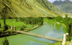
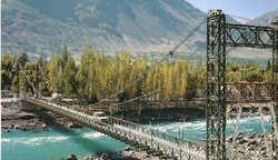
GILGIT is the Capital of Northern Pakistan and a thriving frontier town that has expanded rapidly to include over 40,000 inhabitants since the Karakoram Highway was opened in 1978. It sits in a wide irrigated bowl1500 meters above sea level at the Eastern end of the Gilgit Valley. The quaint little town of Gilgit has a cluster of interesting places in it short radius, including a beautiful rock carving of Buddha, a victory monument of Taj Mughal, built 700 years ago and the longest suspension bridge in Asia ( 600 ft long ) The favorite sport in Gilgit isPolo, which the locals claim originated here. It is a more rugged style than the sedate variety known in the plains. The polo tournament held in the 1st two weeks of November is a festive occasion and attracts a large number of spectators.
GILGIT BAZAAR is famous for its handicrafts such as woolen gowns known as chughas, waist coats, shoes, musical instruments, silver jewelry, caps, woolen rugs and embroideries. The Gilgit town has also become a major dry port for trade between Pakistan and China through Khunjerab Pass. Due to this dramatic reform one can easily purchase China wares, paintings, silk clothes, glass and various other Chinese products of excellent quality. Gilgit town also house the Asia's longest suspension bridge (600 ft long 6 ft wide).
GILGIT BAZAAR is famous for its handicrafts such as woolen gowns known as chughas, waist coats, shoes, musical instruments, silver jewelry, caps, woolen rugs and embroideries. The Gilgit town has also become a major dry port for trade between Pakistan and China through Khunjerab Pass. Due to this dramatic reform one can easily purchase China wares, paintings, silk clothes, glass and various other Chinese products of excellent quality. Gilgit town also house the Asia's longest suspension bridge (600 ft long 6 ft wide).
CHINAR BAGH
where trees as much as 300 years old haughtily overlook the Gilgit river. This beautiful park is adorned with abronze ibex mounted on a tall marble pillar. The monument was built to pay tribute to the local soldiers who sacrificed their lives for the liberation of their motherland.
ISHKOMAN VALLEY
The Ishkoman valley runs north to south to join the Gilgit river at Gakuch, and divides the Karakoram Range from the Hindu Kush. Incorporated in to Pakistan in 1972, Ishkoman was another of the little principalities of the Northern Areas; a vassal of Chitral for the past few centuries. The ex-raja still lives at the capital, Chatorkhand. The population is mostly Ismaili and is the home of an important religious leader. Most people speak Khowar, Shina and Wakhi. It is about 100 kilometers to Chatorkhand, and takes about six hours. The Iskhoman Valley turn-off is at Khanchi Bridge across the Gilgit River, 68 kilometers from Gilgit, just before Gakuch. One can raft from Chatorkhand down to Punial in two days. From Ishkoman one can trek east to Naltar. There are also more difficult treks north to Hunza or Boroghil.
NALTAR
An area of alpine meadows and forests 3000 meters above sea level and surrounded by snow-capped mountains, is the loveliest full-day outing from Gilgit. It is 43 kilometers – about two hours drive from Gilgit. Hidden in the mountains, up a dramatic barren gorge 19 kilometers long, Naltar valley is surprisingly green and lush, and heavily wooded with pine, spruce, birch, rowan and juniper. Some quirk in the climatic conditions gives Naltar about 410 millimeters or 16 inches of rainfall a year, more than three times that of Gilgit.
It is the perfect base for gentle walks through the forest, or you can follow the jeep track up to Naltar Lake, where the fishing is excellent. Naltar is also the starting point for more energetic treks across the passes about 4,600 meters or 15,100 ft. This beautiful meadow also has two ski-lifts operated by Pakistan Army & Air Force and ski courses are conducted from December to March. There are several summer nomadic settlements near Naltar birch poles covered with mud and juniper branches; some are round like a tepree, others oblong with a ridge pole. The entire family comes here for the summer bringing their dogs and chickens. The Gujars also collect birch bark which is used as wrapping paper. Butter is wrapped in the bark and stored in holes in the ground.
It is the perfect base for gentle walks through the forest, or you can follow the jeep track up to Naltar Lake, where the fishing is excellent. Naltar is also the starting point for more energetic treks across the passes about 4,600 meters or 15,100 ft. This beautiful meadow also has two ski-lifts operated by Pakistan Army & Air Force and ski courses are conducted from December to March. There are several summer nomadic settlements near Naltar birch poles covered with mud and juniper branches; some are round like a tepree, others oblong with a ridge pole. The entire family comes here for the summer bringing their dogs and chickens. The Gujars also collect birch bark which is used as wrapping paper. Butter is wrapped in the bark and stored in holes in the ground.
PUNIAL
The fist kingdom to the west of Gilgit is Punial, which encompasses 12 villages and has a population of about 18,000. Its inhabitants call it ‘the place where heaven and earth meet’. Its capital is Sher Qila, 35 kilometers from Gilgit, on the north bank of the Gilgit River. Sher Qila means Lion’s Fort, so cold in winter, so is best visited in spring and autumn.
A 150-year old watchtower, crowned with a pair of ibex horns, stands guard at the end of the ground – a reminder of past wars. The villagers took refuge in the tower whenever attacked. The next important village in Punial is Singal, 16 kilometers further west. Punial is marked with blooming orchards and small terraced fields, traditional blacksmith forges and primitive pitlooms
A 150-year old watchtower, crowned with a pair of ibex horns, stands guard at the end of the ground – a reminder of past wars. The villagers took refuge in the tower whenever attacked. The next important village in Punial is Singal, 16 kilometers further west. Punial is marked with blooming orchards and small terraced fields, traditional blacksmith forges and primitive pitlooms
PHANDER LAKE
PHANDER LAKE is connected by a perilous jeep track via Shandur Pass & Gilgit Valley. At an altitude of 3734 meters, the historic Shandur Pass has been used by the traders for centuries for trading silk between China, Gilgit, Afghanistan and Persia. The perilous jeep road connects to a wide plateau adorned with two serene lakes and thehighest Polo Field in the world. The annual Polo tournament played between the Gilgitis and Chitralis in summer is a festive occasion and attracts spectators from all over the world. Also called the "Angler's Paradise", the serene turquoise colored Phander Lake is full of rainbow and snow trouts. The lake is surrounded by lush green meadows and plantations. This serene lake allows one forget the bumpy and trying jeep journey.
SHANDUR PASS
This picturesque lush green plateau is located at an altitude of 3,734 meters above sea level and it is 12 hours from Gilgit. It is locked by snow from November to May. The first European traveler across the pass, colonel William Lockhart, referred to it as a plateau. This was the route taken by British soldiers on the march from Gilgit to relieve the Siege of Chitral in April 1895. The pass presented considerable difficulties, according to Lieutenant W Benyon, quoted by John Keay in The Gilgit Game. Over the recent years, this pass has gained international popularity due to Mountain Polo Matches held every year from 7th to 10th of July between the centuries old rivalry teams of Gilgit and chitral. The game of polo was invented in this region and it is still played in its original form which is more rugged and rough. Unlike the sedate variety played in the civilized world, there is only one rule of the game : and this is – To Win The Match !
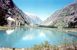
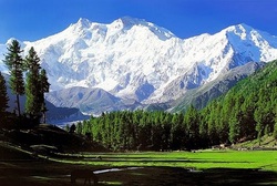
HUNZA VALLEY
Eric Shipton's "The ultimate manifestation of mountain grandeur" the Legendary Hunza - whose very name is overwhelming is known for its towering snow covered peaks, creeping glaciers, fragrant apricot orchards & the longevity of its people. Lord Curson noted that "The little State of Hunza contains more summits of over 20,000 ft than there are of over 10,000 ft in the entire Alps".
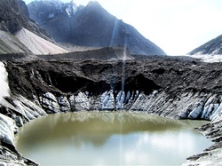
This magical land of contrasting geology abounds in glaciers too, including the 58 Km (world's 5th longest ) Batura Glacier. The Nubra, Braldu, Hushe and Saltoro Rivers are born in the Karakoram glacial vastness: the Shayok River encircles the entire flanks of the range: but only the Hunza river literally cuts through the width of the Karakoram Range. Hunza's extreme isolation thus imposed by the unbelievably steep gorges of the Karakoram, rise to a long standing, wholly indigenous & pure diet consisting almost entirely of apricots, wheat and"Hunza Water", a locally brewed wine, & hence the long living inhabitants.
Until 1974, Hunza remained a semi - autonomous princely state presided over by a benevolent "MIR" who personally held a daily court & the subjects paid taxes in goods rather than money. Nestled under the shadows of Rakaposhi 7788 m, perches its capital Karimabad - guarded with centuries old sentinel of Altit & Baltit. Our approach to Hunza is by jeep on the Karakoram Highway, a thin ribbon of pavement carved into the walls of the stupendous Karakoram. This road completed in 1978 , now links the ancient trails of the Silk Route from Gilgit to Kashgar. Hunza's 35000 inhabitants have been ruled by the same family since the 11th century. A legend relates that the Hunzakuts, (as the people of Hunza are known) are the descendants of the 05 lost soldiers of the Alexander's Army. Brushuski, an aboriginal language is spoken in the central Hunza & Wakhi, related to Chinese Turkistan is spoken in the upper Gojal. Hunzakuts lived off the fruits of caravan- raiding, slave trading & attacking their neighbors. The kingdom retained independence until the British took over in 1891 & became part ofPakistan in 1974. The society is co-operative rather than competitive. Each family grows enough food for its own use. As the Hunzakuts lived aloof from the outer world, each citizen was self sufficient in making his own shoes, clothes & bowls, until, the Karakoram Highway linked them with the world. The people are cheerful & friendly. Almost entire population belongs to the Ismaili Shias sect headed by Prince Karim Agha Khan. The women wear bright clothes, long shirts over baggy trousers & embroided pillbox hats over which they drape their shawls.
KARIMA ABAD
In the lush Hunza valley, the sleepy village of Karimabad is a tourist oasis. The street that winds up to the old Baltit fort is crammed with shops selling local handicrafts such as shawls and carpets, along with local dried fruit, antiques and gemstones.
The people here are Ismaili, which means they welcome music and dancing, and are partial to Hunza water - a spirit made from mulberries - or their homemade Hunza wine. There is also a cafe-cum-bookshop called Café de Hunza that serves real espresso: a treat for caffeine-starved visitors.
Come in spring for the blossom, or autumn to see the rooftops lined with huge rush trays of apricots, tomatoes, apples and spinach drying in the sunshine. A four-hour trek along the irrigation channel that winds up through the village and hugs the rockface up the mountains will take you up to Ultar meadow, where a small makeshift campsite offers views of Ultar peak and glacier.
BALTISTAN
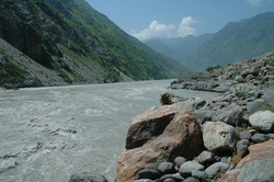
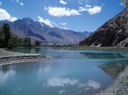
BALTISTAN lies north of Indian-held Kashmir along the Indus River between the Karakoram Mountains and the uninhabited Deosai Plateau. Skardu, its capital, is the starting-point for some of the best trekking and mountaineering in the world. When the Indus River enters Baltistan from Ladakh, it has already travelled 700 kilometers (435 miles) from its source in Tibet. It comes in through a gorge so deep and narrow that no path can follow it. On the northern bank a solid block of mountains, 60 of them over 7,000 meters (21,000 feet) high, from a wall 100 kilometers (60 miles) thick between Baltistan and China. In no other part of the world is there such a large number of high mountains in such a confined space.
On the southern bank, the Himalayas and the Deosai Plateau from the barrier with India. It is only from the west that you can enter the isolated valleys of Baltistan. A new road hugging the bank of the Indus leads from the KKH for 170 kilometers (110 miles) to Skardu. Like the rest of Pakistan's Northern Areas, Baltistan is a high-altitude desert. It rises from 1,500 meters (5,000 feet) above sea level to 8.616 meters (28.268 feet) at the summit of K2, the second-highest mountain in the world. The average rainfall here is less than 100 millimeters (four inches) a year, but wherever possible the steep mountainside is cut into tiny terraces and irrigated by a network of small water channels from the glacier streams. In summer the melting snows swell the Indus to a raging torrent sweeps away everything in its path, so only the gentler side streams can be used for irrigation. Every inch of irrigable land is manured and cultivated: startling green oases stand out against the grey sand and rock of the barren mountains, like emeralds in massive settings of tarnished silver. Stacked up the hillsides near the fields are mazes of multistory wood-and-stone cottages honeycombed with narrow unlit alleyways and rough, dark stairwells. Clustered round the houses are apricot, peach, mulberry and apples trees, all festooned with grape vines. Rows of poplar and willow trees line the irrigation channels and terrace walls, holding the soil in place and providing wind breaks. The trees are also vital for firewood and house building. The quarter million people living in these villages are almost all Shia Muslims, the strictest sect of Islam. They speak Balti, an archaic Tibetan dialect. With its rolling sand dunes and barren mountains, the area round Skardu looks very like Tibet and is, in fact, often called Little Tibet. The valleys are perhaps steeper and deeper than further east; and they are separated not by rolling plateaux but by lofty spurs. Yet there is the same overall impression of rock and sand, harsh white light and biting dry Natural vegetation is a rare and transitory phenomenon; cultivation is just an artificial patchwork of fieldssuspended from a contour-clinging irrigation duct, or huddled on the triangular surface of a fan of alluvial soil washed down from the mountains. John Keay, When Men and Mountains Meet (1977). In comparison to the gentler, greener valleys of Chitral and Hunza, Baltistan appears bleak and forbidding, and is not to everyone's taste. Yet the people, for centuries almost entirely cut off from their neighbors, are charming and hospitable. Until the airstrip was built at Skardu, they were virtually self-sufficient, growing grain and storing rancid butter (a great delicacy) in the ground for the long snow-bound winter. In the summer they ate fruit, reputedly the best in the Northern Areas. As in so many of Pakistan's northern valleys, there is a vague tradition here that the town of Skardu was founded by Alexander the Great. Although the fort at Skardu is sometimes called Askandria (not unlike Skander, Alexander's Indian name), neither Alexander nor his followers travelled this far east. The area's early history is linked to Gilgit's. Baltistan was known as Great Bolor, Gilgit and upper Chitral as Little Bolor, Baltistan comprised four main kingdoms, of which Skardu was the most important. Of the other three, Khaplu controlled the route along the Shyok Valley; Shigar held the Shigar River and its tributaries; and Rondu guarded the Indus Gorge to the west of Skardu. There were also four lesser principalities: Kiris on the Shyok, and Parkutta, Tolti and Kharmang, which were on the Indus and controlled the path to Leh. From 1846 Baltistan was ruled by the maharajah of Kashmir, whose cruel Hindu soldiers were hated by the Baltis. The British were only minimally interested in the area, as they considered it of little strategic value. At Independence in 1947, the Balti people, aided by a small number of freedom fighters, including the Gilgit Scouts, rebelled against their Kashmiri rulers became part of Pakistan. The Kashmiris were for a time isolated within the Askandria Fort.
On the southern bank, the Himalayas and the Deosai Plateau from the barrier with India. It is only from the west that you can enter the isolated valleys of Baltistan. A new road hugging the bank of the Indus leads from the KKH for 170 kilometers (110 miles) to Skardu. Like the rest of Pakistan's Northern Areas, Baltistan is a high-altitude desert. It rises from 1,500 meters (5,000 feet) above sea level to 8.616 meters (28.268 feet) at the summit of K2, the second-highest mountain in the world. The average rainfall here is less than 100 millimeters (four inches) a year, but wherever possible the steep mountainside is cut into tiny terraces and irrigated by a network of small water channels from the glacier streams. In summer the melting snows swell the Indus to a raging torrent sweeps away everything in its path, so only the gentler side streams can be used for irrigation. Every inch of irrigable land is manured and cultivated: startling green oases stand out against the grey sand and rock of the barren mountains, like emeralds in massive settings of tarnished silver. Stacked up the hillsides near the fields are mazes of multistory wood-and-stone cottages honeycombed with narrow unlit alleyways and rough, dark stairwells. Clustered round the houses are apricot, peach, mulberry and apples trees, all festooned with grape vines. Rows of poplar and willow trees line the irrigation channels and terrace walls, holding the soil in place and providing wind breaks. The trees are also vital for firewood and house building. The quarter million people living in these villages are almost all Shia Muslims, the strictest sect of Islam. They speak Balti, an archaic Tibetan dialect. With its rolling sand dunes and barren mountains, the area round Skardu looks very like Tibet and is, in fact, often called Little Tibet. The valleys are perhaps steeper and deeper than further east; and they are separated not by rolling plateaux but by lofty spurs. Yet there is the same overall impression of rock and sand, harsh white light and biting dry Natural vegetation is a rare and transitory phenomenon; cultivation is just an artificial patchwork of fieldssuspended from a contour-clinging irrigation duct, or huddled on the triangular surface of a fan of alluvial soil washed down from the mountains. John Keay, When Men and Mountains Meet (1977). In comparison to the gentler, greener valleys of Chitral and Hunza, Baltistan appears bleak and forbidding, and is not to everyone's taste. Yet the people, for centuries almost entirely cut off from their neighbors, are charming and hospitable. Until the airstrip was built at Skardu, they were virtually self-sufficient, growing grain and storing rancid butter (a great delicacy) in the ground for the long snow-bound winter. In the summer they ate fruit, reputedly the best in the Northern Areas. As in so many of Pakistan's northern valleys, there is a vague tradition here that the town of Skardu was founded by Alexander the Great. Although the fort at Skardu is sometimes called Askandria (not unlike Skander, Alexander's Indian name), neither Alexander nor his followers travelled this far east. The area's early history is linked to Gilgit's. Baltistan was known as Great Bolor, Gilgit and upper Chitral as Little Bolor, Baltistan comprised four main kingdoms, of which Skardu was the most important. Of the other three, Khaplu controlled the route along the Shyok Valley; Shigar held the Shigar River and its tributaries; and Rondu guarded the Indus Gorge to the west of Skardu. There were also four lesser principalities: Kiris on the Shyok, and Parkutta, Tolti and Kharmang, which were on the Indus and controlled the path to Leh. From 1846 Baltistan was ruled by the maharajah of Kashmir, whose cruel Hindu soldiers were hated by the Baltis. The British were only minimally interested in the area, as they considered it of little strategic value. At Independence in 1947, the Balti people, aided by a small number of freedom fighters, including the Gilgit Scouts, rebelled against their Kashmiri rulers became part of Pakistan. The Kashmiris were for a time isolated within the Askandria Fort.
